Located in the shadow of Mount Rainier, two trails give those looking to challenge their fear of heights the ultimate experience. One, located in Mount Rainier National Park, gives hikes a chance to test their merit against a towering, swaying suspension bridge along one of the 11 rivers and major creeks flowing from the iconic and glaciated volcano. The other, to the south of the park, gives those who dare a chance to explore an old lookout tower on a rocky, exposed cliff with breathtaking panoramic views. Both are perfect for visitors who are heading into Mount Rainier National Park‘s east entrance, which leads to Longmire and Paradise.
The hikes mentioned are not for everyone, but should be attempted by anyone looking to have a unique experience while in the natural beauty of the Pacific Northwest. Numerous rescues have occurred at these locations from people unable to move, paralyzed by the sheer drop visible. That may convince a few of you not to hike these trails, but for the majority of those looking for impressive pictures, amazing views and awesome destinations, these hikes make for a perfect getaway any day of the week. Hike them often, and share them with your friends, as they make for truly unique Pacific Northwest adventures.
TAHOMA CREEK SUSPENSION BRIDGE
HIKE IS NOT FOR BEGINNERS AND THOSE UNCOMFORTABLE WITH ROUTE FINDING.
If you have ever watched Indiana Jones and the Temple of Doom and wished you could cross a impressive suspension bridge, then this is the trek for you. For adventure crossing a high bridge near Mount Rainier, the Tahoma Creek Suspension Bridge give willing to hike a few miles along Tahoma Creek not just an incredible location for Instagram posts, but also shows a unique view of a mountain quickly identified as the Pacific Northwest’s most iconic mountain. Located on the Wonderland Trail, a 95-mile loop trail that circles the entire mountain, the Tahoma Creek Suspension Bridge sways with each step and each gust of wind coming down from the snowy slopes. Hovering 200 feet above the creek below and stretching over 150ft from cliff to cliff, the bridge is not for those faint of heart. Small gaps between the wooden planks of the bridge groan and creak with every step, giving those making the trek across this gorgeous bridge. Hikers more adventures can work their way up to Emerald Ridge for a dazzling display of wildflowers in the summer and a magnificent view of Mount Rainier.
Directions: http://goo.gl/maps/86Vog
Distance: 6.4 miles round trip
HIGH ROCK LOOKOUT
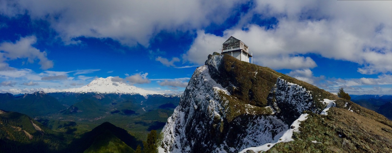
High Rock Lookout may be one of the most underrated hikes around the Mount Rainier region. Located on a craggy peak, this old lookout tower built in 1925 now is vacant, seeing signs of weathering and the inevitable vandalism that comes from being an abandoned building in the wilderness. The lookout itself isn’t the destination, or even the main draw to the trail. Instead, hikers who climb up the 1,365 feet are rewarded with one of the more exposed, dizzying panoramas in Washington State. To the south, the grade is somewhat gentle, giving views of forested hills, as well as the summits of Mt St Helens, Mount Adams, the Goat Rocks and Mount Hood. These views are impressive, but most who come to High Rock end up looking north and west, and these are the best views of the exposed, sheer cliffs. Dropping nearly a thousand feet in places, the rocky outcropping get you up close and personal with the Nisqually River Valley and a breathtaking view of Mt Rainier. Be aware that the exposed ledges have caused numerous visitors severe vertigo, with a handful of Search and Rescue operations occurring each and every year. At High Rock, pose for pictures, peer over the edges, but remember to be extremely careful, as a fall here will kill you.
Directions: http://goo.gl/maps/NXXox
Distance: 3.2 miles round trip


