This week in Yellowstone National Park, from April 2nd to April 8th, 2026, I try to convince you to find dead things, tell you about an app to download that will make your park experience even better, tell you about Cooke City, and highlight a unique seasonal walk on a closed road. I will also give you the complete weather forecast, the snowpack update, the wildlife report, and everything else you need to have an incredible time, “This Week in Yellowstone.”
LISTEN TO THIS AS A PODCAST
Apple: https://podcasts.apple.com/us/podcast/this-week-in-yellowstone-national-park/id1789397931
Spotify: https://open.spotify.com/show/41E5WWldz4s7n6NXh2Lahr
RSS: https://rss.com/podcasts/this-week-in-yellowstone-national-park/
Disclaimer: I may miss a few details, so please feel free to reach out with any questions. I also mention park locations casually. If you’re unfamiliar, a quick search can help. This report only covers drivable areas of the park.
Also, this podcast is a passion project. If you enjoy it, I’d love a review or a quick email! To support my work, check out my hiking and wildlife-watching guidebooks, or join me for a guided hiking tour in Yellowstone’s backcountry. For more information, visit outdoor-society.com or contact me directly. Seriously though, come book a trail tour with me.
EXPERIENCE OF THE WEEK
Wildlife Watching at Carcasses and Kills
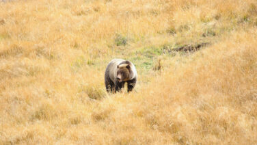
If you’re in Yellowstone National Park right now, one of the most compelling wildlife experiences right now is centered around carcasses. This is when wolves, newly emerged bears, and scavenger birds all converge, creating some of the most dynamic wildlife viewing of the year.
Wolves are often the starting point for excitement on carcasses. A single kill can hold a pack’s attention for days. According to the National Park Service and Yellowstone Wolf Project reports, wolves can consume large quantities at once, sometimes up to 15 percent of their body weight in a single feeding, before returning repeatedly to the carcass. That repeated use makes these sites reliable places to observe behavior over time.
Bears are now also entering the picture in a major way. Early April lines up closely with the emergence of grizzly bears from their dens, especially adult males, often referred to as boars. These larger males are typically among the first bears to come out of the dens. After months without eating, they are in a significant caloric deficit. Research cited by the National Park Service shows that grizzly bears can lose 15 to 30 percent of their body weight during hibernation, depending on age, sex, and conditions. For a large boar, that can easily mean one hundred pounds or more lost over the winter.
Because of that, carcasses become one of the most important early-season food sources. They provide high-calorie nutrition without the energy cost of hunting. It’s common for a grizzly to take over a carcass from wolves, and studies have shown that bears frequently dominate these encounters, displacing wolves and controlling access to the food source. Watching that interaction unfold is one of the more intense wildlife experiences available in Yellowstone right now.
Above the ground-level action, scavenger birds are constant. Ravens are usually first, often arriving quickly and staying in groups around the carcass. Bald eagles and golden eagles follow, along with magpies. These birds depend heavily on carcasses in early spring, especially before insect and plant food sources become widely available. The National Park Service notes that ravens in particular are closely linked to wolf activity because they rely on wolves to open carcasses they cannot access on their own.
If you’re trying to locate one of these sites, focus on the signs. Circling birds, clusters of ravens in trees, or wolves holding in one area are often the first indicators. In open landscapes like the Northern Range, these cues can be spotted from a distance with optics.
There is also an important management component. When carcasses are too close to roads, Yellowstone staff may move them short distances away. This helps reduce the risk of dangerous wildlife jams and prevents bears and wolves from becoming too accustomed to feeding near people. According to the National Park Service, these relocations are done to protect both visitors and wildlife while still allowing natural behavior to continue.
Right now, carcasses are where much of the best wildlife watching action is. Wolves feeding, boar grizzlies recovering from winter weight loss, and birds working every opportunity around them. If you come across a carcass, take your time watching it and keep your distance. The park requires at least 100 yards from bears and wolves. These are high-energy, competitive situations, and animals will defend what they’ve found. Because of this, limit your noise and movement as best you can. Don’t go from pullout to pullout chasing the animals as they move. Give them a break and do your part to help them stay as calm and natural as possible while they feed.
TIP OF THE WEEK
Get the Merlin App
If you’re heading into Yellowstone National Park, there’s one simple thing you can do ahead of time that can completely change how you experience the park: download the Merlin Bird ID app.
At first, it might sound like something meant only for serious birders. Or people interested in being considered birders. It’s not. Merlin is built for anyone and everyone, whether you’ve never identified a bird in your life or you already know a few. It’s easy to use, and more importantly, it helps you notice things you’d otherwise miss. Having the Merlin App in the park will help transform quiet moments of sitting by rivers or at pullouts into a fuller experience, bringing the park to life even more.
The feature most people end up loving is Sound ID. You just open the app, hit record, and it starts listening to the world around you. As birds call, the app identifies them in real time. In a place like Yellowstone, where there’s constant background sound in forests, along rivers, and across open valleys, this can completely shift your experience. What used to feel like general noise suddenly becomes specific and recognizable.
The app is developed by the Cornell Lab of Ornithology, which is one of the leading bird research organizations out there. Merlin pulls from a huge database of recordings and observations, including data from eBird, so it’s not just guessing. It’s built on real science and continues to improve over time (cornelllab.org).
If you’re visiting in April, this becomes even more useful. Yellowstone is starting to chirp with bird activity this time of year. You might hear osprey, sandhill cranes, western meadowlarks, bluebirds, or see bald eagles near water, while songbirds move through forests and meadows. Merlin doesn’t just tell you what you’re hearing; it starts to help you understand patterns. You’ll notice which birds stick to rivers, which prefer open sagebrush, and which stay tucked into the trees.
One thing that makes Merlin especially useful in Yellowstone is that it works offline. Before your trip, you can download the regional bird pack, and once that’s on your phone, you don’t need service. That matters here, since cell coverage in the park is very limited.
There’s also a simple ID tool if you actually see a bird. The app asks a few quick questions, like size, color, and behavior, then gives you a shortlist of likely matches. It’s fast and easy, which is exactly what you want when a bird doesn’t stick around for long.
What ends up happening is that Merlin naturally slows you down, in a good way. You start paying attention to things you might have ignored before. A quick stop becomes something you linger at. A quiet morning turns into something more active and engaging, just by listening.
The National Park Service regularly encourages visitors to look beyond the big animals and connect with the park on a broader level. The Merlin App helps with this goal of the park. Birds are a huge part of Yellowstone’s ecosystem, and they’re everywhere once you start noticing them.
It’s a small step to download the app before your trip, but it can make a big difference. Once you start using Merlin, Yellowstone feels more detailed, more interactive, and a lot more alive. Chances are, you’ll start using it all the time, and then you’ll slowly become a birder, which will either improve your life greatly or make you a bird nerd searching for lifers, both of which are wins in my book.
RANDOM YELLOWSTONE FACT OF THE WEEK
The History of Cooke City
The story of Cooke City begins long before mining claims or cabins appeared in the Absaroka Mountains. Indigenous peoples, including the Crow and Shoshone, moved through this high country for generations, following seasonal game and navigating routes that connected valleys and plateaus across what is now southern Montana and northern Wyoming. The region’s harsh winters and rugged terrain limited permanent settlement, yet it remained an important travel corridor.
Everything changed in the late 1860s, when prospectors pushed deeper into the mountains during the broader Montana gold rush. Reports of mineral deposits drew attention to the area northeast of what would soon become Yellowstone National Park, setting the stage for Cooke City’s founding.
By the early 1870s, small mining camps had formed in the area. The town was named after Jay Cooke, a financier tied to Northern Pacific Railroad interests, reflecting early hopes that industry and infrastructure would follow mineral discovery. People such as Nathaniel P. Langford helped publicize both Yellowstone and the surrounding mineral potential, encouraging further investment and exploration.
Gold and silver deposits were present, but extracting them proved difficult. According to historical accounts and mining records, the short summer season and heavy snowfall limited how long miners could work each year. Supplies had to be hauled over long distances, and isolation made sustained development challenging. While some mines produced modest yields, the area never reached the productivity seen in other Montana mining districts (Montana Historical Society).
Still, optimism remained high. By the late 1870s, Cooke City had developed into a rough frontier settlement with cabins, saloons, and a small but determined population.
Cooke City’s future hinged on transportation. In the late 19th century, serious efforts were made to extend rail lines into the region. Investors believed that connecting Cooke City to national markets would unlock its mining potential and transform it into a major hub.
However, multiple factors intervened. Financial setbacks, including the collapse of railroad financing tied to Jay Cooke, stalled progress. At the same time, the establishment and protection of Yellowstone created political resistance to rail development through the park. According to the National Park Service, early debates about access and preservation played a role in limiting infrastructure expansion in and around Yellowstone.
Without a railroad, Cooke City remained isolated. This moment marked a turning point. Instead of becoming a booming industrial center, the town settled into a quieter, more uncertain future.
Mining continued into the early 20th century, but success remained inconsistent. Harsh winters, limited access, and fluctuating mineral prices led to repeated cycles of activity and decline. Some operations persisted, producing gold and silver on a smaller scale, but large-scale development never materialized.
During this period, Cooke City began to take on a new role. It became a stopping point for travelers heading toward Yellowstone’s remote northeast corner. Its location kept it relevant, even as mining declined. Small businesses, supply operations, and seasonal activity helped sustain the community through difficult decades.
A major transformation came with the construction of the Beartooth Highway in the 1930s. Built in part by the Civilian Conservation Corps, the highway connected Cooke City to Red Lodge and opened a dramatic high-elevation route across the Beartooth Plateau.
The impact was immediate and lasting. What had once been an isolated mining town became a gateway for travelers. The highway, now recognized by the U.S. Forest Service as an All-American Road, brought visitors drawn by alpine scenery, wildlife, and access to Yellowstone’s Northeast Entrance.
Tourism gradually replaced mining as the town’s economic foundation. Lodges, services, and seasonal businesses began to shape Cooke City’s future. What is somewhat humorous is that some locals still bemoan tourism in Cooke City, as if it hasn’t been the only industry in town for decades upon decades.
Despite improved summer access, winter remained a defining challenge. Heavy snowfall closes the Beartooth Highway each year, often from October through late May, leaving Cooke City accessible primarily from the Wyoming side near Yellowstone. This seasonal isolation shaped the town’s identity.
Over time, that challenge became an asset. Cooke City developed a reputation as a winter destination, particularly for snowmobiling and backcountry recreation. Its remote setting, deep snowpack, and proximity to wilderness areas attract visitors seeking a quieter, more rugged experience.
Today, Cooke City remains small, with a year-round population of fewer than 100 residents. It serves as a gateway to one of Yellowstone’s most wildlife-rich regions, including Lamar Valley. While remnants of its mining past still exist in historic structures and abandoned claims, the town’s economy is now built on tourism and outdoor recreation.
Cooke City never became the industrial center that early investors had imagined. Instead, it evolved into something more enduring. Its history is one of ambition, setbacks, and adaptation, shaped by geography, climate, and its close relationship with Yellowstone. For visitors, that history is still visible in the landscape, in the buildings, and in the quiet resilience of the community itself.
WEATHER FOR THE COMING WEEK
I am too lazy to type it all out, so you’ll have to listen to the podcast to get the weather forecast, or just contact me.
Apple: https://podcasts.apple.com/us/podcast/this-week-in-yellowstone-national-park/id1789397931
Spotify: https://open.spotify.com/show/41E5WWldz4s7n6NXh2Lahr
RSS: https://rss.com/podcasts/this-week-in-yellowstone-national-park/
SNOWPACK UPDATE
As of April 1st, the snowpack is around 83% of normal for this time of year. The eastern and northern ranges of the park are 95% of normal, while the western and southern sides are 68% of normal. Last year on this date, we were averaging around 100% of our normal level.
ROADS CONDITIONS
The only road open is the road between Gardiner, Montana, and Cooke City, Montana. Please be aware that this road can close at any time due to inclement weather.
For up-to-date information, call (307) 344-2117 for recorded information, or sign up to receive Yellowstone road alerts on your mobile phone by texting “82190” to 888-777.
CAMPING INFO
There is only one campground open in the park right now, and that is the Mammoth Campground, which is open year-round.
WILDLIFE WATCHING UPDATE
You have to listen to the podcast to get this information. Sorry.
Apple: https://podcasts.apple.com/us/podcast/this-week-in-yellowstone-national-park/id1789397931
Spotify: https://open.spotify.com/show/41E5WWldz4s7n6NXh2Lahr
RSS: https://rss.com/podcasts/this-week-in-yellowstone-national-park/
PICK UP A GUIDEBOOK
Love what you have heard on this podcast and want more information on wildlife watching? Get a copy of my wildlife-watching guidebook to the region! Available in both ebook and paperback formats, my book will help you spot wildlife like a seasoned local. Please consider buying a book directly from me, as I make next to nothing when they are sold on Amazon. Grab your copy now!
TRAIL ALERTS AND UPDATES
There are no official trail alerts this week. Those will be resuming in April. Right now, bear sightings are becoming more common and will only be increasing with every passing week. Carry bear spray. Have it readily accessible and not in a backpack. Know how to use it.
TREK OF THE WEEK
The Road up to Calcite and Tower: Now (Mostly) Snow-Free!
Walking the road from Roosevelt Junction to Tower Fall in this early spring window, when the pavement is clear but the route is still closed to cars, is one of those experiences that almost feels like you are breaking rules. It’s about 2.65 miles each way, and without traffic, it turns into a quiet, easy walk through one of the more geologically interesting and panoramic view stretches of Yellowstone National Park.
Right from the start, the biggest difference is the lack of noise. As soon as you leave the junction, all unnatural noise fades away. In a month, this road will be busy, with people rushing back and forth, looking at the falls and hoping to catch a sighting of bears. Right now, though, it’s just you, the sound of the wind, and the growing roar of the Yellowstone River far below.
As you make your way toward Tower, the views start to open up, but the real standout along this route is the geology. Not far into the walk, you’ll pass sections of columnar basalt cliffs, where ancient lava flows cooled and cracked into vertical, hexagonal columns. These formations are the result of slow-cooling volcanic rock, and they give this stretch of road a completely different feel compared to other parts of the park. It’s the kind of feature most people drive past without noticing, but when you’re walking, you actually stop and take it in.
About halfway along, you reach one of the highlights of the entire route: Calcite Springs. This is one of my favorite viewpoints in the park, and one I go to dozens of times a year. At Calcite, you get to take in stunning views of the Yellowstone River as it cuts deep through dark volcanic rock, moving fast, especially this time of year, as snowmelt starts to build. Informative displays tell you the geological history, as well as pointing out layers of ash from previous volcanic events. The view looking west is also stunning, showing off a bend in the river by Bumpus Butte, where steam rises from the springs along the riverbank.
After enjoying Calcite, which you should walk the whole thing, the walk to Tower continues with more open views as you get closer to the waterfall. Sweeping views emerge, and with no cars or people around, there is no rush to move on. Stop and scan the cliffs across the way for wildlife, as it is often seen here. Arriving at Tower Fall without crowds is a completely different experience. The falls drop about 132 feet over jagged volcanic rock, surrounded by those sharp spires that have been shaped by erosion over thousands of years. Normally, it’s a quick stop with people coming and going. This time of year, you can actually stand there and take it in.
The walk to Tower itself isn’t difficult, but it’s still early spring. You might run into patches of snow, ice, or water running across the road. Just be prepared for changing conditions, even on paved routes, and you’ll be fine. Also, always have bear spray. This area will increase with bear activity every week, and by mid-May, it will have numerous bear sightings.
What really makes this stretch special right now is the timing. The weather won’t be great this week, but this trek will be. It always is. For a short period each year, this road shifts from a busy connector to something quiet and immersive. This is an easy walk, giving you access to geology, views, and a version of Yellowstone that most people never slow down enough to see. Plus, you may even see bison, bighorn sheep, and maybe a bear! When hiking this, please park near the pit toilets at Roosevelt and walk up the road.
NEXT WEEK
In the next episode, I’ll return with all of the information you need to have a good week in the park, including wildlife, weather, and trail updates. Until then, book a tour with me, pick up a guidebook of mine, and happy trails!