Residents of Washington State are spoiled with beauty and probably more spoiled than anywhere else in the nation. Washingtonians have access to the most incredible scenery in America, just 90 drive minutes away from nearly every major city. To the north, south, west and east, we have no shortage of jaw-dropping destinations. Even often over-looked Eastern Washington is full of amazing places to see, explore and discover. Yet, when most people think of Washington State, they think of the westside: the wet side, the green side… You know, the side with the mountains.
In Western Washington, active volcanoes, glaciated summits and craggy peaks dot the landscape, with rain-soaked valleys collecting water for salmon-filled rivers and breathtaking waterfalls. From sea to summit, the westside is beautiful, and one main reason is the mountains. The mountains of Washington State are far too numerous to be climbed in a lifetime; yet, we all search and strive to reach them all. Filling the horizon, thrusted up from plate-tectonics, the peaks of Washington are responsible for destruction and beauty, agony and relief. For many in the outdoor community, the mountains of Washington serve as reminders of strength, lustful goals, and act as challenges for those who test their merit against the elements.
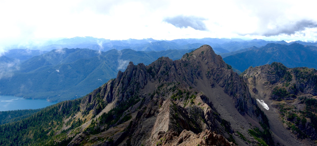
Living in Washington, we all have our favorite mountain areas. For some, it is the high alpine wonderland of Mount Rainier. For others, it is the alps-style beauty of the North Cascades. For me, it is the Olympics in their rain-soaked grandeur. From Olympia, I can be in the Olympic Mountain range, exploring rugged peaks and experiencing all the levels of mountaineering, just 90 minutes from my door. My home range is the mountains around the Staircase Region of Olympic National Park, which includes a wide variety of awesome adventures for all levels of mountain lovers. From a popular mountain with the best panoramic view in Washington State, to a pair of seldom-explored summits worthy of love and care, you will find a favorite. There are more than six peaks in the Staircase Region, but the following handful are sure to keep you coming back to the area time and time again. If you haven’t hiked these, check them out in weather conditions you can handle. If you have stood at the top of them all, come back and watch them in the snowy and rainy seasons.

Mount Washington
Elevation: 6,260 feet
Distance: 4 Miles Round Trip
Approx. Elevation Gain: 3,000 feet
Style: Scramble
Route: Experienced Route Finders Only. Details.
Mount Washington in the Olympic Mountain Range is one of two Mount Washington’s in Washington State. The Olympic’s Mount Washington is a scramble, from start to finish. With exposed ledges, steep inclines, scree fields and route finding skills needed, this is not a climb for the unfamiliar. However, for those with knowledge of shambles and the route, Mount Washington is worth the effort. After climbing up steep slopes, hikers are rewarded with stunning views of the entire Puget Sound, every major mountain in Washington State, the city of Seattle and breathtaking views of the Olympic Interior. This might just be the best day climb in the Olympics, and with numerous routes to the summit, one could spend a months exploring the area. Again, this is not for beginners. Be aware that the weather changes quickly. Read Route Info.

Mount Ellinor
Elevation: 5,944 feet
Distance: 4 Miles Round Trip
Elevation Gain: 2,400 feet
Style: Day Hike in Summer
Route: Easy to follow during summer months. Details.
Mount Ellinor is one of the most popular mountains to climb in all of Washington State, drawing well over 20,000 hikers each year. With a superbly maintained trail, wildlife encounters and one of the best panoramic views in the west, this trail is a fair weather hikers dream trail. Sure, it is steep, but prepared hikers of nearly all levels can reach the summit, if they take their time. Awaiting those who reach this peak are amazing views of the entire Pacific Northwest, including glimpses of Mounts Rainier, Baker, St Helens, Adams and Olympus. On a clear day, Seattle can be seen along the Puget Sound, while mountain goats climb on rocks all around. Mount Ellinor can he hiked year round, but crampons and an ice axe are required during the snowy days. Winter ascents of Ellinor are not for beginners. Read More.

Mount Rose
Elevation: 4,300 feet
Distance: 6.5 Miles Round Trip
Elevation Gain: 3,500 feet
Style: Hike
Route: Easy to follow. Head right at the fork for a more gentle incline. Details
Mount Rose has a bad reputation of being steep and difficult, yet, I have hiked this trail with families who have young kids. The key to this mountain is patience, as the trip can be a bit long and tedious. The trail starts off near the banks of Lake Cushman, before steadily climbing over three thousand feet to the 4,300 foot mark. Along the trail, hikers will have a decision to make once they reach a fork in the trail. My recommendation is to head right, as it is less steep and weaves you toward the summit. Left heads basically straight up, and is quite the leg burner. Once at the summit, hikers are rewarded with views of Lake Cushman, Mount Rainier, Mount Adams and Mount St Helens in the distance. This hike is accessible most of the year, and is a great introductory mountain in the Olympic Range. Read More.

Cub Peak
Elevation: 4,755 feet
Distance: 6.8 Miles Round Trip
Elevation Gain: 4,000 feet
Style: Hike and Scramble
Route: Easy to follow to Wagonwheel Lake, then a boot path up. Details.
Cub Peak is a rarely climbed summit in the Olympic Range, and despite me writing about it constantly, it remains infrequently visited. People don’t avoid the mountain because it is ugly, or because it is so remote. Instead, they take one look at the elevation gain and the warning sign at the trailhead and turn back. Cub Peak stands nearly 1,000 feet above Wagonwheel Lake, one of Olympic National Parks steepest short hikes. Gaining 4,000 feet in 3.4 miles, many view reaching this summit as masochistic, but they are wrong. Summiting Cub peak might be a bit insane, but the views at the summit are spectacular. From the precarious peak, inspiring views of Mount Pershing, Mount Washington, Mount Ellinor, Copper Mountain and Sawtooth Ridge await, as well as a gorgeous view down the Hamma Hamma River Valley. The trail to Wagonwheel Lake is easy to follow, but finding the boot path to Cub peak can be tough. Read more.

Copper Mountain
Elevation: 5,425
Distance: 8 Miles Round Trip
Elevation Gain: 4,800 feet
Style: Hike and Scramble
Route: Easy to follow to Wagonwheel Lake, then a scramble to the summit. Experienced Route Finders Only. Details.
Copper Mountain is another tough hike and scramble that splits off from the Wagonwheel Lake Trail in Olympic National Park. Steep, without a well-marked route, Copper Mountain tends to be skipped often by the flocks of tourists that visit the Staircase Region. Yet, those who do bushwhack and route find from Wagonwheel Lake are rewarded with a fun scramble and awesome views of the Staircase Region. From the summit of Copper Mountain, with its 1,300 feet of prominence, the panoramic view is hard to beat. It might not be as stunning as Ellinor or Washington, but Copper Mountain gets dedicated hikers and climbers a unique view of the greater Lake Cushman area. At the peak, take in views of Lake Cushman, Mounts Rainier, Adams, St Helens, Ellinor, Washington, Pershing, Rose and even Cub Peak, as well as the entire Olympic Range. More info.

Mount Gladys
Elevation: 5,589 feet
Distance: 20 Miles Round Trip
Elevations Gain: 4,800 feet
Style: Long Hike
Route: Easy to follow to Gladys Divide, boot path to summit. Details.
No hike in the Olympic Range is as amazing as the route to get to the summit of Mount Gladys. The trail starts along the amazing Staircase Loop Trail, before heading up past Donahue Creek Falls and reaching Flapjack Lakes. From there, the path becomes less traveled, though a well-maintained trail will lead you all the way to Gladys Divide. Gladys Divide is one of the best destinations for a long day hike in Olympic National Park, and adding the stunning views from Mount Gladys makes it a must experience mountain destination. From the summit, unrivaled views of the entire Olympic Range open up, with Mount Olympus looking in the distance. Behind you, the stunning Sawtooth Ridge juts up into the sky, seemingly out of place with the rest of the terrain. Mount Gladys is completely underrated, and those who can handle the distance and elevation gain will be greatly rewarded. More info.
WANT MORE ADVENTURES IN AND AROUND OLYMPIC?
Discover a Hike a Week through our Olympic National Park Area Guidebook


