This week in Yellowstone National Park, from March 19th to March 25th, 2026, I will share with you why Blacktail Ponds is a great place to go this week and over the next month or so, I’ll tell you why a 50 degree day in Yellowstone’s northern range will feel so much warmer, try to convince you to appreciate Undine Falls, and even share an easy hike just outside of the park that I love and think you will too. I will also give you the complete weather forecast, the snowpack update, the wildlife report, and everything else you need to have an incredible time, “This Week in Yellowstone.”
LISTEN TO THIS AS A PODCAST
Apple: https://podcasts.apple.com/us/podcast/this-week-in-yellowstone-national-park/id1789397931
Spotify: https://open.spotify.com/show/41E5WWldz4s7n6NXh2Lahr
RSS: https://rss.com/podcasts/this-week-in-yellowstone-national-park/
Disclaimer: I may miss a few details, so please feel free to reach out with any questions. I also mention park locations casually. If you’re unfamiliar, a quick search can help. This report only covers drivable areas of the park.
Also, this podcast is a passion project. If you enjoy it, I’d love a review or a quick email! To support my work, check out my hiking and wildlife-watching guidebooks, or join me for a guided hiking tour in Yellowstone’s backcountry. For more information, visit outdoor-society.com or contact me directly. Seriously though, come book a trail tour with me.
THIS WEEK’S YELLOWSTONE NEWS
Oversnow Travel Is Over For the Winter
As of the 15th of March, all oversnow travel for the winter of 2025-26 is over. The park is now transitioning to opening interior roads, which is scheduled to start on April 17th.
EXPERIENCE OF THE WEEK
Go Scan Blacktail Ponds
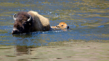
In March, Blacktail Ponds becomes one of the more compelling places to witness the transition from winter to spring in Yellowstone National Park. The ponds, just a few miles east of Mammoth, sit in a broad, open valley along the park’s northern range, where snowpack is often lighter than at higher elevations. As winter ends and spring days become more common, the wetland itself starts to change. Ice from cold mornings may still cling to the shaded edges, but the ponds themselves are melting and are showing off their winter capture. I’ll probably recommend doing this a few times this year, but this week could be a good one.
Each year, bison frequently cross the ponds and surrounding boggy flats during seasonal movements. All winter long, some animals become trapped in the mud or icy water and are unable to escape. According to the National Park Service, natural winter mortality is an important ecological process in Yellowstone, and carcasses left on the landscape provide a vital food source for scavengers and predators. At Blacktail Ponds, this process can be especially visible. This winter, three bison are said to have died at Blacktail Ponds, each frozen and hidden during the winter. Now that spring is here, they are becoming visible again.
For that reason, the area is sometimes associated with some of the first prolonged grizzly bear sightings of the season. Adult male grizzlies often emerge from hibernation in March, weeks before females with cubs. These early bears are drawn to winter-killed animals that offer high-calorie meals after months of fasting. Bison carcasses in and around the ponds can become focal points for feeding activity. Eagles, both bald and golden, ravens, magpies, and coyotes are often the first clues that something is happening, their calls carrying across the open valley long before a bear is visible.
The ponds themselves have a stark, quiet character at this time of year. During these few weeks of shoulder season, fewer visitors travel this stretch of road in early March, and the setting can feel remote despite being close to a main route through the park. By early April, if bears are nearby, the main pullout fills up before sunrise. Right now, though, you could be here alone or with a handful of others. However, if a grizzly is feeding, expect the area to be quite busy.
Wildlife watchers typically scan the ponds from roadside pullouts along the Mammoth-to-Tower section of the Grand Loop Road. A signed overlook provides one of the best views into the marsh, while additional turnouts nearby allow for patient observation of distant movement. Early-morning and late-afternoon light often reveals animals more clearly against the pale backdrop of snow and grass.
Short hikes on either side of the ponds bring visitors closer to the surrounding landscape, though travel is rarely easy in March. Snow, mud, and standing water are common, and conditions can change quickly with temperature swings. Anyone exploring on foot should carry bear spray and remain alert. The potential to encounter a feeding grizzly in this area is real during the early spring weeks.
Blacktail Ponds in March is not defined by lush scenery or comfortable trails. Instead, it offers a powerful look at how Yellowstone’s ecosystem works at the end of winter. Carcasses nourish bears and scavengers, thawing wetlands signal the coming season, and the wide northern range provides a stage for one of the park’s most dramatic annual transitions.
TIP OF THE WEEK
Sunshine and Elevation: Why Yellowstone’s 50-Degree Days Feel So Warm
As you will hear in the weather report a bit later, this week is expected to be quite warm in Yellowstone, with highs in the 50s in the park and maybe even the 60s or 70s in Gardiner. Most of you will be hearing those numbers and scoffing, as 50 degrees isn’t warm in most of the country. While that is true, a 50-degree day in Yellowstone hits differently.
A sunny 50-degree day can feel surprisingly warm on the northern range of Yellowstone National Park, even though that same temperature might feel chilly in many lower-elevation places. Part of the reason comes down to altitude. Much of Yellowstone’s Northern Range sits well above 6,000 feet, and some areas are even higher. For example, Lamar Valley sits about 6,500 feet above sea level, according to the National Park Service. At elevations like this, the atmosphere is thinner, which allows more of the sun’s energy to reach the ground.
Scientists and public health organizations note that ultraviolet radiation increases with elevation, often by roughly 4 to 12 percent for every 1,000 feet gained. This means sunlight can feel noticeably stronger in the mountains than at sea level, even when the air temperature remains cool. Standing in full sun on a calm March afternoon can feel surprisingly warm, especially after a long winter. Now, I know some of you are doubting this, but every single year, people tell me I am correct on this. Before their trips from warm areas, they will email me, telling me that 60 degrees is chilly and they will be fine. Yet, they will get here in March, the high will be 50 or 60, and they will tell me how hot it was. Maybe you’ll tolerate it better, but the majority of people I talk to have now experienced how much warmer everything feels at elevation in Yellowstone.
The clarity of mountain air also plays a role. Compared with many urban or coastal areas, Yellowstone’s high valleys often have very dry, clean air. With fewer particles to scatter sunlight, more direct solar radiation reaches the landscape. Wide open views across sagebrush flats or grassy hillsides leave visitors fully exposed to that sunshine. If snow is still covering parts of the ground, the light can feel intense, even causing you to get a burn from the reflection. Trust me on this. Getting a sunburn on your nostrils is as fun as it sounds.
Bright snowfields can reflect a large percentage of incoming solar radiation, sometimes as much as 80 percent. That reflected energy reaches people from below as well as above, creating a kind of radiant warmth that feels stronger than the thermometer suggests. This is one reason people sometimes feel warm enough to shed layers while standing in sunlight, only to cool quickly when stepping into shade or wind.
Seasonal timing matters, too. By mid-March, the sun is climbing higher in the sky compared with midwinter. Longer days and a stronger solar angle mean more concentrated sunlight reaches the ground during midday hours. Even though overnight temperatures may still drop below freezing, afternoons can feel mild and inviting. The change is often noticeable across the northern range, where snow begins to soften, wildlife becomes more active, and the landscape starts hinting at spring.
Wind conditions can make an especially big difference. When breezes are light, south-facing slopes and sheltered pullouts along the park road can warm quickly under direct sun. Dark soil, rock, and vegetation absorb heat and release it back into the surrounding air, creating small pockets of localized warmth. Move a short distance into shade or into a gust of cold air, and the temperature can feel dramatically different.
There is also a simple human factor for those of us who live in the mountains. After months of deep winter, a day in the upper 40s or low 50s feels like a turning point. Visitors and wildlife alike respond to the shift. Bison begin lingering longer on exposed hillsides, birds become more vocal, and people find themselves lingering at overlooks just to enjoy the sensation of sunlight on their faces.
Taken together, high elevation, strong ultraviolet exposure, reflective snow, clearer air, and the seasonal return of longer days help explain why a 50-degree afternoon in Yellowstone can feel far warmer than expected. It is one of the small but memorable pleasures of visiting the park’s northern range in late winter or early spring.
RANDOM YELLOWSTONE FACT OF THE WEEK
Undine Falls and Lava Creek
Undine Falls is one of the most accessible and quietly scenic waterfalls in Yellowstone National Park. Although smaller than some of the park’s famous cascades, it has a rich geological story, a layered naming history, and a distinctive place in the landscape of Yellowstone’s northern range. Despite all of this, many guidebooks to the region omit the falls and creek, or tell you to skip stopping at the area. More often than not, the authors and editors of these books are only focused on their version of must-see regions, not encouraging visitors to stop everywhere and to find their own moments of natural beauty and bliss in nature.
Undine Falls lies along Lava Creek, about four miles east of Mammoth Hot Springs on the road toward Tower Junction. The falls are visible from a roadside pullout and overlook, making them one of the easiest waterfalls in the park to view. The waterfall drops through a narrow gorge in three distinct plunges, reaching a total height of roughly 60 feet. Lava Creek continues downstream for about a mile before joining the Gardner River, placing the falls within the broader drainage of Yellowstone’s northern range.
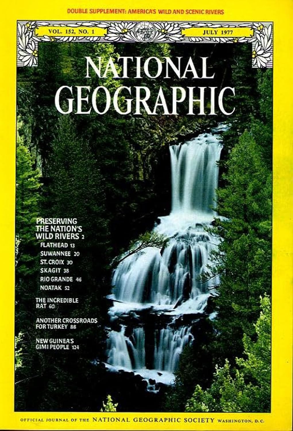
Despite its modest height compared with Yellowstone’s famous canyon waterfalls, Undine Falls has appeared in park publications and even on the cover of the July 1977 issue of National Geographic. For a waterfall that some say isn’t worthwhile to even stop at and see from the easy pullout, this is a fun fact to point out.
Like many Yellowstone waterfalls, Undine Falls owes its existence to ancient volcanic processes. Lava flows that occurred roughly 700,000 years ago created resistant basalt layers that now form cliffs and ledges. As Lava Creek cut downward through softer rock, these harder lava deposits formed the stepped drops that shape the waterfall today. The result is a classic multi-tiered plunge waterfall, where water fans over successive rock shelves before collecting in the gorge below.
The name “Undine Falls” has a surprisingly specific origin tied to late-19th-century exploration. Early visitors and surveyors sometimes referred to the waterfall by other names, including East Gardiner Falls or Gardiner River Falls, reflecting confusion about local waterways.
The modern name was reportedly given in 1885 by geologist Arnold Hague, a member of the U.S. Geological Survey team studying Yellowstone’s volcanic landscape. He chose the name “Undine” after water spirits from German mythology. These mythical beings were often portrayed as female figures associated with springs, rivers, and waterfalls. The poetic name reflects a broader pattern in Yellowstone’s early exploration era, when scientists and explorers frequently drew on classical or mythological themes when naming natural features.
Undine Falls is best known as a roadside scenic stop. A signed pullout allows visitors to walk just a short distance to an overlook that provides a clear view of the entire waterfall. However, few know that the nearby Lava Creek Trail offers additional perspectives. This longer trail system runs about 4.2 miles one-way as a through-hike down to the Gardiner River, but for the purpose of appreciating Undine Falls, it can be seen as a one-mile round-trip hike to the top of the falls and canyon rim. Please know that if you do hike here, and anywhere in Yellowstone, expect wildlife on the trail, carry bear spray and have it readily available, and know how to use it.
Its layered drops, mythological name, and easy accessibility have made it a memorable landmark for generations of visitors. Many travelers pass the overlook without realizing the falls are there, adding to the sense that it remains a relatively hidden gem along a major park road.
Undine Falls represents a convergence of Yellowstone themes: volcanic geology, early scientific exploration, wildlife habitat, and accessible scenic beauty. Its name preserves a fragment of nineteenth-century imagination, while its setting along Lava Creek illustrates how water continues to sculpt the volcanic plateau. In a park known for massive waterfalls and geyser basins, Undine Falls stands out not because of size, but because of the way it quietly connects geology, myth, and travel history along one stretch of road.
WEATHER FOR THE COMING WEEK
As always, this is the best forecast for the week at the time of recording. The forecast can change numerous times in a week, but this should be within the ballpark of what you’ll experience when visiting the park.
I am too lazy to type it all out, so you’ll have to listen to the podcast to get the weather forecast, or just contact me.
Apple: https://podcasts.apple.com/us/podcast/this-week-in-yellowstone-national-park/id1789397931
Spotify: https://open.spotify.com/show/41E5WWldz4s7n6NXh2Lahr
RSS: https://rss.com/podcasts/this-week-in-yellowstone-national-park/
SNOWPACK UPDATE
As of March 17th, the snowpack is around 105% of normal for this time of year. The eastern and northern ranges of the park are 113% of normal, while the western and southern sides are 85% of normal. Last year on this date, we were averaging around 104% of our normal level.
ROADS CONDITIONS
The only road open is the road between Gardiner, Montana, and Cooke City, Montana. Please be aware that this road can close at any time due to inclement weather.
For up-to-date information, call (307) 344-2117 for recorded information, or sign up to receive Yellowstone road alerts on your mobile phone by texting “82190” to 888-777.
CAMPING INFO
There is only one campground open in the park right now, and that is the Mammoth Campground, which is open year-round.
WILDLIFE WATCHING UPDATE
You have to listen to the podcast to get this information. Sorry.
Apple: https://podcasts.apple.com/us/podcast/this-week-in-yellowstone-national-park/id1789397931
Spotify: https://open.spotify.com/show/41E5WWldz4s7n6NXh2Lahr
RSS: https://rss.com/podcasts/this-week-in-yellowstone-national-park/
PICK UP A GUIDEBOOK
Love what you have heard on this podcast and want more information on wildlife watching? Get a copy of my wildlife-watching guidebook to the region! Available in both ebook and paperback formats, my book will help you spot wildlife like a seasoned local. Please consider buying a book directly from me, as I make next to nothing when they are sold on Amazon. Grab your copy now at outdoor-society.com!
TRAIL ALERTS AND UPDATES
There are no official trail alerts this week. Those will be resuming in April. Right now, bear sightings are becoming more common and will only be increasing with every passing week. Carry bear spray. Have it readily accessible and not in a backpack. Know how to use it.
TREK OF THE WEEK
Yankee Jim Canyon
Accessed from the west side of Yankee Jim Canyon, this figure-eight-shaped trail puts you in the steps of the indigenous populations that called the region home, as well as lets you walk along the original road that led tourists to Yellowstone. Found at the Southern end of Paradise Valley, just below Tom Miner Basin, the Yankee Jim Canyon Trail is one that nobody, aside from a handful of locals, wanders.
After locating the trailhead parking lot, which is nothing more than a clearing off the dirt road and is unsigned, you have two choices. The easiest is to park and then walk down the dirt road to the river, following the old railway grade upstream. Follow this path for 1.5 miles or so. Along the way, you’ll be above the river, so keep an eye out for wildlife, especially osprey and eagles. You’ll also pass through the parking area for the Sphinx Creek Picnic Area and an old cabin. Once beyond the parking area, at the 1.5 to 1.6-mile mark, keep an eye out for an old road on the right. It will look more like a boot path at this point. Take this path.
Along the path, you’ll come across interpretive signs, as well as old advertisements for Gardiner and Yellowstone spray-painted on rocks. This is the original road to visit Yellowstone. This is only half a mile long before it drops back down to meet the main path, but it is definitely a hidden gem and something few ever see.
Once you reach the main path, follow the river downstream and retrace your steps to the car. In total, this is about 4 miles with around 400 feet of elevation gain.
I am recommending this trek outside of the park for a few reasons. The first is that the trails in the park will be quite muddy. If that isn’t a deterrent for you, let me know, and I can recommend other hikes. The second reason I think you’ll like Yankee Jim right now is the birding and wildlife potential. Last week, while driving to the trailhead and hiking the trail, I saw about one hundred elk, some common mergansers, a dozen bighorn sheep, and a couple of eagles. This time of the year, you may also see bluebirds, sandhill cranes, meadowlarks, and more animals. Thirdly, which is a word but shouldn’t be, the temperatures are increasing this week and weekend, leading to snowmelt and helping raise the river a bit. It will be super scenic, I promise.
If you want more information on this hike or other hikes in and out of Yellowstone, please contact me, as I have a guidebook specifically for this. It covers over 50 of my favorite hikes in the region, with something for every month of the year. Trust me, it is awesome.
NEXT WEEK
In the next episode, I’ll return with all of the information you need to have a good week in the park, including wildlife, weather, and trail updates. Until then, book a tour with me, pick up a guidebook of mine, and happy trails!