Mount Rainier Park tends to get overlooked by everyone, which is a funny thing to say about a volcano rising over 14,409 feet above sea level. Mount Rainier is one of the most visible and iconic mountains in North America, and is located 54 miles from the city of Seattle, which sits just above sea level. Each year, Mount Rainier has tens of millions of eyes gaze upon the glaciated summit during the sunny days, when locals say “the Mountain is out.” Everyone who lives near the mountain knows its shape by memory, and yet, few travel to this National Park and mountain.
I know many of you will scoff, but numbers don’t lie. Mount Rainier received 1,264,259 visitors in 2014, ranking it as the 14th most-popular of the 59 national parks, according to the LA Times. Think 1,264 259 is a lot of people? Olympic National Park, further from an airport or major city, received 3,243,872 and was the 6th most-popular National Park in America. Have you heard of Washington State’s Lake Roosevelt National Recreation Area? It received 1,180,898 visitors in 2014. Only 83,270 people difference from the crown jewel of the Pacific Northwest and a lake formed in 1941 by the creation of the Grand Coulee Dam. I have been to Lake Roosevelt and it is truly beautiful, but it doesn’t compare to Mount Rainier.
The lack of visitation to Mount Rainier confuses me, but I suppose it is understandable. Many who visit this National Park a few hours drive from Seattle see Paradise and Longmire, stopping at Reflection Lake, the numerous waterfalls and pull-offs. We do this once or twice and assume we have seen Mount Rainier. That is where many fall short in truly discovering the beauty of the park.
Mount Rainier is more than just Paradise, it is more than just driving the roads. Mount Rainier offers hundreds of experiences, trails and places to explore, and we want to get you out into the mountains.

Pack Forest Waterfalls Trail
Distance: 6 miles round trip
Location: http://goo.gl/maps/6HSuX
Why: Technically not in Mount Rainier National Park, millions drive past the Pack Forest toward Longmire, without realizing they are driving away from incredible forests and gorgeous waterfalls. This dog-friendly trail is amazing year-round, but is best seen after a heavy rain. Be safe and know your footing if you decide to take a risk and explore closer to the falls.

Mount Fremont Lookout Trail
Distance: 5.6 miles round trip
Location: http://goo.gl/maps/J85HF
Why: Located above the popular Sunrise region of Mount Rainier National Park, the Mount Fremont Trail is rarely visited compared to the huge numbers who walk the mower walkways around Sunrise Visitor Center. The views from the Fremont Lookout Trail are drool worthy, showing off Mount Rainier, and even Mount Baker on a clear day. Keep an eye out for mountain goats and the rare glimpses of the city of Seattle.

Dege Peak Trail
Distance: 4 miles round trip
Location: http://goo.gl/maps/J85HF
Why: It isn’t every day that you can reach a peak that overlooks a glaciated volcano, but the short trip to Dege Peak is a mountain top accessible by nearly everyone. Easy to hike, but offering unrivaled views, Dege Peak would be the most popular mountain hike in Washington if it was closer to a city. Each step offers great views of Mount Adams, Mount Rainier, making this a photographers ideal location.

Spray Park
Distance: 6 miles round trip
Location: http://goo.gl/maps/gdiXR
Why: Spray Park is located near Mowich Lake, an often overlooked destination in the Northwest Region of Mount Rainier National Park. Located at the end of a dirt road, the trail to Mowich Lake is one of the most iconic hikes of the park. With wildflowers, marmots, meadows and incredible views, taking the side trails around Spray Park will make it one of your all-time favorite easy day hikes.

Kelly Butte Lookout Trail
Distance: 3.4 miles round trip
Location: http://goo.gl/maps/OkcNA
Why: Located in the Mount Baker-Snoqualmie National Forest north of Mount Rainier National Park, the short trail to the Kelly Butte Lookout is one of the best side trips in the area. Leading to a historical mountain-top cabin, the trail offers incredible views of Mount Rainier, as well as the valley below. The trailhead can be hard to find, so make sure you print/save good directions.

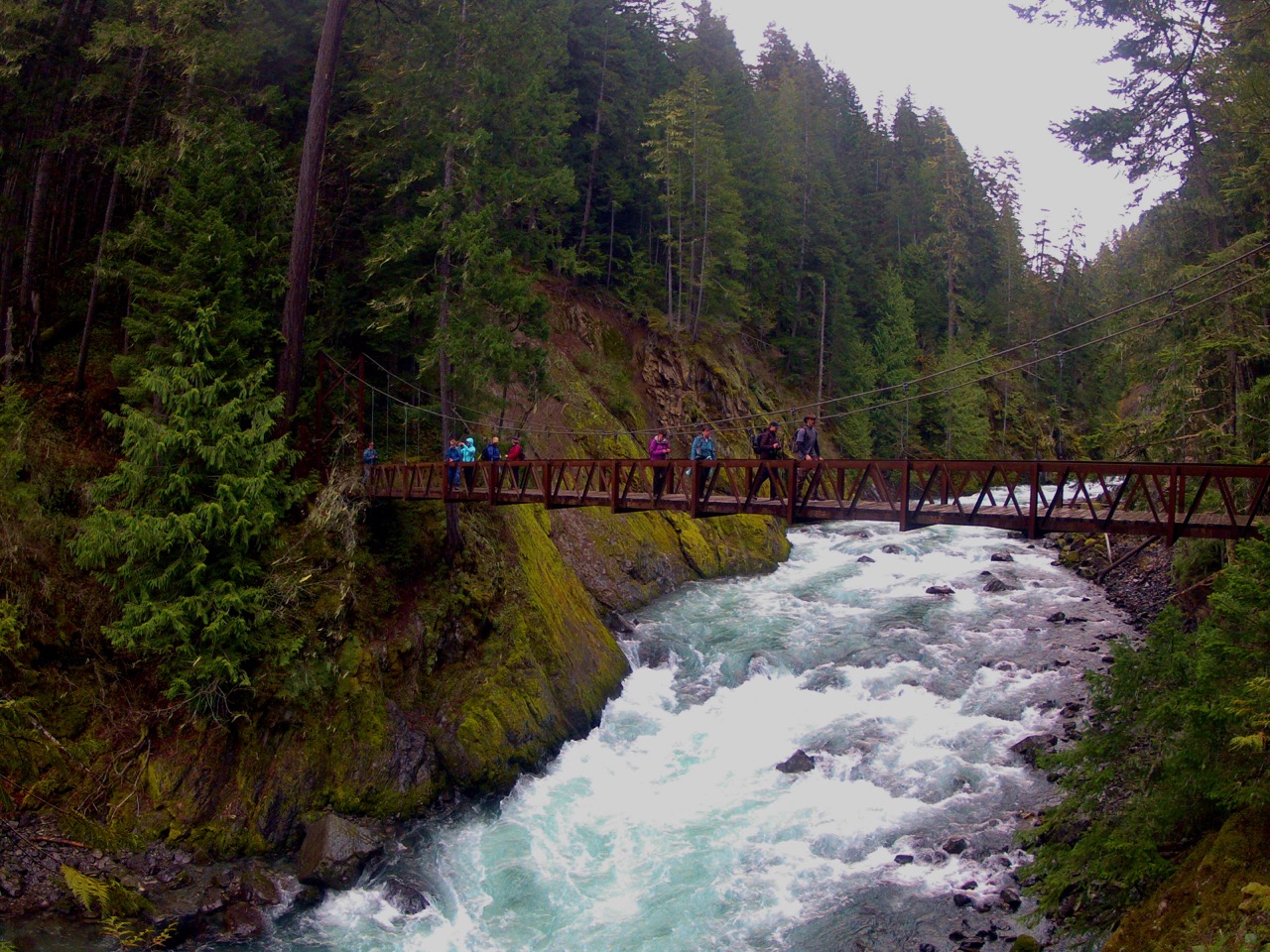
Tahoma Creek Suspension Bridge
Distance: 6.4 miles round trip
Location: http://goo.gl/maps/86Vog
Why: Many drive past the road to this trailhead when they go to Longmore and Paradise, yet few actually take the trip down Westside Road. Once more popular, a washout limited access to the region, making this the perfect day hike destination. The trail follows Tahoma Creek upstream, eventually arriving at one of the more iconic and accessible cable bridges along the Wonderland Trail. This isn’t for the faint of heart, as the bridge can be quite unnerving for those with a fear of heights.

Highrock Lookout
Distance: 3.2 miles round trip
Location: http://goo.gl/maps/NXXox
Why: Highrock Lookout gives those who take the short hike uphill an amazing experience at one of the more unique destinations in the world. Perched upon a steep knife-ridge, High Rock Lookout precariously perches over the Nisqually River Valley a few thousand feet below. Stunning views of Mount Rainier, Mount Adams, Mt St. Helens and even Mount Hood are possible, but be aware the steep drop has been known to give people vertigo so bad they require being rescued.

Ohanapecosh and the Grove of Patriarchs
Distance: 1.5 miles round trip
Location: http://goo.gl/maps/bQGmR
Why: The Grove of Patriarchs is a popular hike that many know of, but it always worth mentioning, especially for those looking for an amazing, family-friendly hike. The trail is simple and straight forward, taking you across a fun cable bridge and into an old growth forest with huge trunks and ancient trees. The trail has boardwalks through the forest and pathways around the tallest of trees, giving great experiences around these giants.

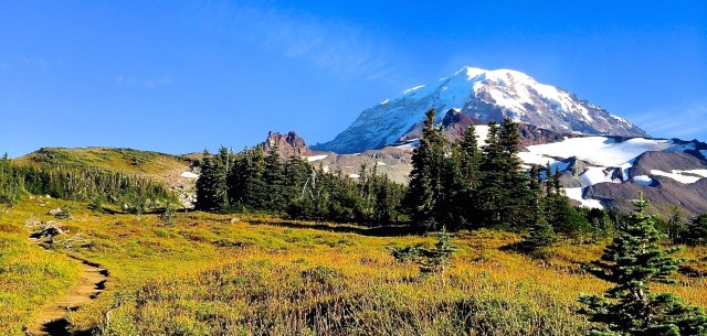
Tipsoo Lake and Naches Peak Loop
Distance: 3 miles round trip
Location: http://goo.gl/maps/6gu8V
Why: While many will argue that this trail is also quite popular, very few people actually hike the loop trail. Starting at the always scenic Tipsoo Lake, head clockwise on the loop trail for the more majestic views. During the summer months, the area erupts in wildflowers, making it an ideal, high alpine loop hike that is fun for the family. With amazing views of Mount Rainier, and the cascade mountains, this hike is sure to be a memorable trip on the eastern side of the park.