This week in Yellowstone National Park, from June 12th to June 18th, I share a secret corner of the park that most visitors to Yellowstone have never even heard of, rant about a few bear incidents the park experienced last week, help you prepare for the heat at elevation for your summer trip, and share a perfect trail for this coming week. I will also give you the wildlife report and everything else you need to have an incredible time, “This Week in Yellowstone.”
LISTEN TO THIS AS A PODCAST!
Apple: https://podcasts.apple.com/us/podcast/this-week-in-yellowstone-national-park/id1789397931
Spotify: https://open.spotify.com/show/41E5WWldz4s7n6NXh2Lahr
RSS: https://rss.com/podcasts/this-week-in-yellowstone-national-park/
Disclaimer: I might miss a few details, so feel free to reach out with questions! I also mention park locations casually—if you’re unfamiliar, a quick search can help. This report only covers drivable areas of the park.
Also, this is a passion project—I’m not paid or sponsored. If you’re enjoying it, I’d love a review or a quick email! To support my work, check out my guidebooks on hiking and wildlife watching, or join me for a guided Yellowstone tour. For details, visit outdoor-society.com or reach out directly! I currently have quite a lot of availability in July, so if you want to hike with a guide, hit me up!
THIS WEEK’S YELLOWSTONE NEWS
Numerous unconfirmed reports of people feeding, approaching, and handling bears in Yellowstone.
Every so often, I share something from social media here. Usually, I don’t bother until there is an official press release. However, this week I am making an exception. Instagram user takethescenicroutewithus, who knows Yellowstone extremely well, reported the following on a recent post:
“Yesterday was a doozy of bad decisions in the park related to bears… First I heard was that a sow with two cubs was being fed. I assume this was the beryl due to the location. Report mentioned that the people feeding her and the cubs were 25ft from the bear. Then, in the evening, I hear from friends that someone was seen holding a black bear cub elsewhere in the park. This is a yearling that is due to separate from its mother soon. Then, bear management makes a post about these two events, along with a third where folks were feet from obsidian and her three cubs.”
There is no reason not to believe these reports. Visitors in the park have a history of behavior like this in the park and have been doing so for decades. Hell, 60 years ago, this was a common practice in the park. Now, it would be easy to blame a lack of funding for these incidents, but that isn’t the case. The park is staffed quite well, and even if there were a ranger every mile of park roads and trails, incidents would still occur.
The issue has nothing to do with funding or staffing; it doesn’t really even have to do with the education of visitors. Instead, this behavior comes from entitlement. People do what they want and consequences be damned.
Speaking of consequences, one major issue I have with law breakers in the park is that when caught, they more often than not get a slap on the wrist- a small fine, a park ban for a year or two, and maybe a day or two in jail. Want an example?
In 2019, three Montana men who crossed into Yellowstone National Park to kill a mountain lion were fined about $1,700 each and placed on three years of unsupervised probation. During that time, they were also banned from hunting, fishing, or trapping worldwide. Biologists estimate that 20-31 adult cougars reside year-round in Yellowstone’s northern range (an average of 12-18 females and 8-13 males).
If these people who handled the bears and fed the bears are caught, this is what will happen to them—a laughable punishment for the humans, potentially a death sentence for the bears. Many will hope that when people do this, the bears will attack. If the bear attacks, the bear will be killed. If the bear gets fed too much, the bear will be killed. The person will maybe get attacked, but more than likely get minimally punished, and the cycle of behavior will continue.
I could rant about this for hours, but I won’t. What I will say is to be vigilant about helping maintain proper viewing distances with wildlife. If you see someone break the rules, take a picture of them, their car, and their license plate, and report it all to the rangers as soon as possible. Also, I know Congress has a lot of other things to deal with, but maybe it’s time we work to give some teeth to the laws in our National Parks, as that may be the only solution to mitigating behavior like this.
Finally, please remember that out of the 4.5 million visitors to the park each year, only a small handful are doing awful things like this. The overwhelming majority are following the park’s rules and regulations and being truly awesome. Let’s not lose sight of that.
Oh, and as I am typing this, I am getting word that on June 10th, a 30-year-old man from New Jersey was gored by a bison near Old Faithful after a group of visitors approached it too closely. He sustained minor injuries. This is the second bison goring of 2025, the same number as 2024.
EXPERIENCE OF THE WEEK
The Bechler Region
The Bechler region of Yellowstone, tucked away in the park’s remote southwest corner, offers an experience that feels worlds apart from the crowded boardwalks and traffic jams of the main park roads. This is Yellowstone in its most natural, unspoiled state, a place where waterfalls thunder in hidden canyons, wildflowers bloom in untouched meadows, and thermal features bubble quietly deep in the backcountry, without an audience. Getting there requires a bit of effort, but that’s exactly what makes it so special. The journey, whether you’re driving through the Mesa Falls Scenic Byway or approaching from the south through Caribou-Targhee National Forest, builds a sense of anticipation. It’s as if you’re entering a secret entrance to the world’s first national park.
For those who crave solitude and connection with nature, Bechler is a revelation. Known as Yellowstone’s “Cascade Corner,” this region is home to more waterfalls than anywhere else in the park, many of them accessible by quiet, scenic trails that wind through lush forests and river valleys. Just be aware that the trails will be boggy, muddy, and full of mosquitoes well into the late summer months. Trails like the Bechler River and Boundary Creek paths offer access to hidden gems like Dunanda Falls and Union Falls, waterfalls so majestic they feel almost mythical. Wildlife sightings are frequent and intimate here; elk, moose, and even bears roam the backcountry with little human interruption. And unlike the main areas of the park, you’ll often have the trail, or even an entire waterfall, all to yourself.
But perhaps the greatest reason to drive to Bechler is the feeling it leaves with you: a sense that you’ve touched something rare and wild, something that most people will never see. In a world increasingly shaped by convenience and overexposure, Bechler reminds you of the value of going further, slowing down, and experiencing nature on its own quiet terms. It’s not just a place you visit, it’s a place that stays with you, long after you’ve left its rivers and forests behind. For the adventurous spirit and the wilderness seeker, Bechler isn’t just worth the drive, it’s the reason you came to Yellowstone in the first place.
After passing the Warm River area, a peaceful spot popular for picnics and fishing, the paved road transitions into Forest Road 582, also known as Cave Falls Road. This gravel stretch leads you toward the southwestern entrance of Yellowstone. Though the road is passable in most vehicles during dry conditions, it’s wise to drive slowly and be prepared for dust, potholes, and no cell service. Once you reach the Cave Falls area, you’ll be rewarded with one of Yellowstone’s widest waterfalls, a broad curtain of water just 20 feet high but stretching nearly 250 feet across the Fall River. This part of the park is known as the “Cascade Corner” thanks to its abundance of waterfalls and backcountry trails, and it remains one of Yellowstone’s least-visited areas.
The Cave Falls area is perfect for quiet hiking, photography, and wildlife watching, especially if you’re hoping to avoid crowds. If you’re planning to explore on foot, bear spray is a must, and trails like the short hike to Bechler Falls offer easy access to some of the region’s natural beauty. Just make sure to check road conditions before you go, especially in spring or after heavy rains, and bring everything you need for the day; there are no services beyond Ashton. All in all, it’s a peaceful, rewarding drive into one of Yellowstone’s best-kept secrets.
Bonus: Driving the Mesa Falls Scenic Byway. Between Ashton and Island Park, the journey gets even more rewarding as you turn east onto the Mesa Falls Scenic Byway, a beautifully maintained road that winds through the Caribou-Targhee National Forest. This byway leads you away from the main highway traffic and into a world of dense forest, rolling hills, and volcanic geology. The highlight, of course, is the pair of waterfalls, Lower and Upper Mesa Falls, where the Henrys Fork crashes over ancient lava flows. Upper Mesa Falls, in particular, is a must-see, with its 114-foot plunge into a basalt gorge, viewed from an easy-access boardwalk and overlook. Along the route, you’ll also pass the Warm River area, a calm and charming spot popular for picnics, fishing, and spotting wildlife.
TIP OF THE WEEK
Managing Heat and Elevation in Yellowstone
Without fail, the end of spring and the start of summer bring about a whole new set of things to deal with when visiting Yellowstone. While fall and winter have snow and cold, this time of the year has the sun and warmth. Some of you listening may be from hot places, but I can assure you, the heat at elevation hits a little differently.
Elevation along Yellowstone National Park’s roadways averages about 7,500 feet above sea level, though this can vary quite a bit depending on where you are in the park. Some of the lower sections, such as the area near the North Entrance at Gardiner, Montana, sit around 5,300 feet. On the other end of the spectrum, the highest point on a paved road in the park is Dunraven Pass, which reaches an elevation of roughly 8,859 feet between Tower Junction and Canyon Village.
Popular destinations like Old Faithful and Lake Village are generally in the 7,300 to 7,800-foot range, while the West Entrance and Madison Junction sit slightly lower, around 6,600 to 6,800 feet. The Northeast Entrance near Cooke City is about 7,000 feet in elevation, though surrounding roadways often climb higher into the Absaroka Range.
Some will tell you that because Yellowstone is at an elevation, it will feel and be cooler than at sea level. That is partially true, and I get the logic, but it is also partially false. Most of the park on a hot summer day is uncomfortable for all, even with our low humidity. Last year, I had a few people on a tour from the south. I gave them the weather forecast for our hike a day before, and they responded by telling me that they would be just fine; they are used to heat and humidity, and dry heat is easy to handle. Even when we met in the morning, they laughed off my warning about the heat at elevation. We were an hour into our hike, and the high temperature started to impact them. They were extremely uncomfortable in the warmth and told me they should have taken the heat at elevation more seriously. This happens to me numerous times a summer. I also constantly overhear people in the park, shocked at how hot 70 degrees feels.
Being at elevation will make your body work harder than it normally would for simple tasks, due to less oxygen. If you are coming from sea level to Mammoth, which is one of the lower spots in the park, you will be experiencing a decrease in oxygen effectiveness of 4.3%. It is definitely not the 14% you lose at the top of Mount Everest, but it is still noticeable to the majority of visitors to the park.
How should you handle this? The solution is pretty easy. Get plenty of rest, stay hydrated, give your body energy with good foods, and move a little slower. One tip I do tell a lot of people when booking tours is that if they can, give themselves a day or two to get used to the elevation before doing a strenuous activity. While this may not always be possible, if you can, definitely consider it.
Also, wear a hat, a sunshirt, put on sunscreen, and use chapstick with an spf. Bring a bandana and soak it with cold water when you can. The elevation will dry you out, so keep pounding fluids. It is better to always need to pee than to get heat exhaustion.
Finally, the younger you are, and the better shape you are in, the less you may feel the elevation, and therefore the less you will feel the heat. Still take it seriously, though. Come in overprepared.
RANDOM YELLOWSTONE FACT OF THE WEEK
Sometimes my facts are going to be short, and this is one of those times. Today, I am briefly talking about touring the park. Initially, traveling to and around the park was pretty rough. It wasn’t until 1883 when the Northern Pacific Railroad reached all the way down to Cinnabar, just north of Gardiner, that things got a little easier. I stress a little here.
A typical tour would take visitors from the train station on “Tally-Ho” stage coaches, up through the Gardner River Canyon to Mammoth Hot Springs. After checking into the hotel in Mammoth, they would take a tour of the hot springs, then spend the next four days going around the park on passenger coaches called Yellowstone Wagons. These wagons were rugged at best, forcing riders to exit the vehicle on steep inclines and descents. However, each night, visitors would stay in a nice room with a good bed and fresh food. Hotels were all over the park, but over time, they were rendered useless as travel became easier. Some were torn down, some burned down, and only a few stayed standing.
Those early visitors told everyone they knew, sending letters and postcards sharing their ordeal, helping to spread the popularity of the park near and far. The railroads advertised the park, helping build the reputation and daydreams of seeing the wonders of Yellowstone firsthand. The current figure eight we now know as the upper and lower loop roads, was completed in 1905, helping visitors more easily travel around the park. It wouldn’t be until 1915 that the first automobile entered the park, forever changing tourism and helping create the way we now visit the park.
ROADS CONDITIONS
All major roads are open right now in and around Yellowstone National Park. This includes Dunraven Pass and the Beartooth Highway.
For up-to-date information, call (307) 344-2117 for recorded information, or sign up to receive Yellowstone road alerts on your mobile phone by texting “82190” to 888-777.
WILDLIFE WATCHING UPDATE
You have to listen to the podcast to get this information. Sorry.
Apple: https://podcasts.apple.com/us/podcast/this-week-in-yellowstone-national-park/id1789397931
Spotify: https://open.spotify.com/show/41E5WWldz4s7n6NXh2Lahr
RSS: https://rss.com/podcasts/this-week-in-yellowstone-national-park/
PICK UP A GUIDEBOOK
Love what you have heard on this podcast and want more information on wildlife watching? Get a copy of my wildlife-watching guidebook to the region! Available in both ebook and paperback formats, my book will help you spot wildlife like a seasoned local. Please consider buying a book directly from me, as I make nothing when they are sold on Amazon. Grab your copy now at outdoor-society.com!
TRAIL ALERTS AND UPDATES
Blacktail and Recue Creek currently have a bear warning. Lava Creek has numerous carcasses and bears frequenting the trail. Storm Point is closed due to an aggressive bear. The Howard Eaton trail near Fishing Bridge has an aggressive bear warning, as well.
I share this information, not to tell you where to see a bear, but to tell you to stay away from these areas. This information is up-to-date, as of the morning of June 10th. All the information on trail conditions can be found on the Backcountry Situation Report of Yellowstone National Park.
TREK OF THE WEEK
Garnet Hill
I constantly share hikes that I say are my favorite hikes, and this week is no exception. The following is a direct excerpt from my hiking guidebook to the region. I highly encourage you to pick up a copy.
The Garnet Hill Loop is by no means a secret. The trail is a favorite of rangers and seasonal employees, seeing moderate use during the summer. Despite that, you’ll see very few people while hiking this loop trail. I recommend parking at the large parking area near the gas station and the pit toilets, then walking along the road to the north trailhead, just before the road to Lamar turns toward the bridge. This will have you hiking this loop counter-clockwise, and giving you what I think is the best experience.
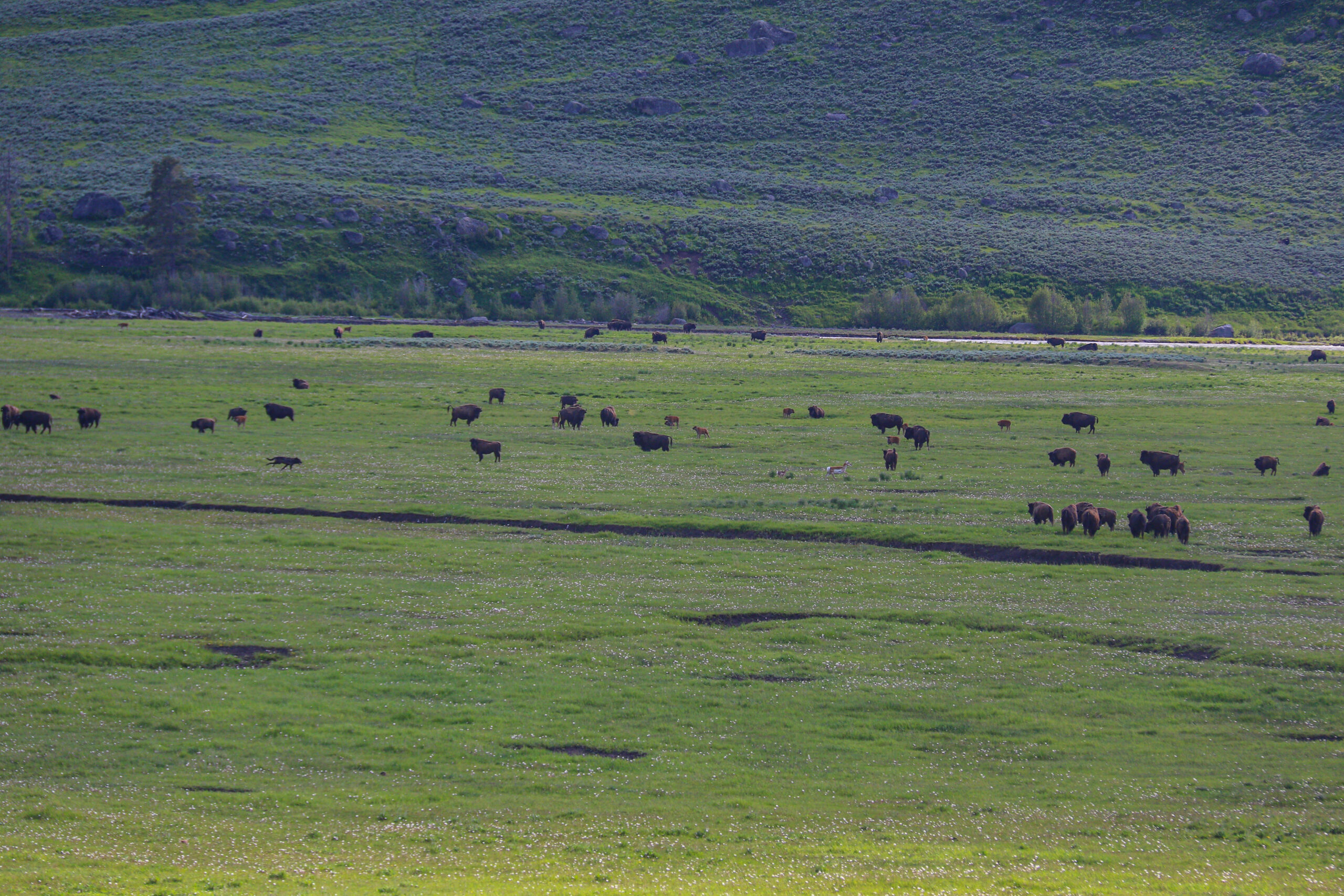
The first mile or so of the hike gains 135 feet of elevation, topping out around 6,400 feet. Along this stretch of trail, you’ll wander through sage, passing boulders discarded by the glaciers of the last ice age. Bison and coyotes are commonly seen around here, as are sandhill cranes, eagles, hawks, and occasionally, bears. Around two miles into the hike, the trail starts to drop toward the Yellowstone River. By mile three, you are below 6,000 feet and are hiking next to the river on one side and the side of Garnet Hill on the other. Please know that this section of the trail is narrow, and you’ll often encounter wildlife also using the trail. Give them plenty of room to pass and always stay an appropriate distance from them.
Around mile four, after a bit of an uphill stretch, you’ll enjoy a great view of the Yellowstone River, which I often use as a spot to snack and take a break. This is also a good spot to check in with how you are feeling and decide whether you want to take the detour to the Hellroaring Suspension Bridge. At mile 4.5, you reach a junction. Here, you can either hike back to Roosevelt and complete the loop, or you can hike half a mile each way to get to the bridge and back. Once you are back at the junction, head toward Roosevelt by following the trail along Elk Creek. You’ll pass cool rocks, places with marmots, and some welcome shade. Be aware that this section of the trail is quite narrow and is a frequent location for bears to hang out. Make lots of noise, have your bear spray ready, and make lots of noise. Yes, I said that twice on purpose.
Around mile 6 or 7, depending on whether you hiked to the suspension bridge or not, you’ll emerge from the forest and get back into the prairie. This is where you’ll reach an area known as Yancey’s. In 1884, John Yancy built a small hotel here called the Pleasant Valley Hotel. In 1906, it burned to the ground and was not rebuilt. However, the area is now a destination for stagecoach riders, cookouts, and horseback riding trips from Roosevelt. In the summer, expect to see horseback tours, people on stagecoaches, and maybe a flock of humans dining on chili and other cookout snacks while confused bison look on. From Yancey’s, follow the stagecoach road back to the road and finish the loop hike.
The total distance for this hike is around 9 miles with about a thousand feet of elevation gain.
NEXT WEEK
In next week’s episode, I’ll return with all of the information you need to have a good week in the park, including wildlife, weather, and trail updates.
Until then, happy trails!