There is nothing quite like wandering the wintery wonderland of Yellowstone National Park’s Northern Range on foot. While you’ll be able to see a lot of amazing things from the comfort and warmth of your car, the experiences found on a pair of cross-country skis or snowshoes will leave you longing to get out into the cold every chance you get. You’ll see frozen waterfalls, amazing wildlife, and stunning canyons and potentially have life-changing experiences out in the wilds of Yellowstone.
I could and will happily, upon request, share dozens of amazing winter hikes, but for brevity’s sake, I wanted to share eight winter trails that are sure to get you excited about winter wandering in Yellowstone. These six hikes, some short and some longer, are the best way to get away from the roads of Yellowstone National Park’s Northern Range in the Winter months. Along these routes that go beyond the boardwalks, you’ll see wildlife, as well as the splendor of Yellowstone up close and personal.
Don’t have gear for these hikes? Let me guide you with one of my winter wonderland tours of Yellowstone! I provide the expertise, snowshoes, and even backpacks with snacks and water. All you have to do is show up and be ready to be amazed.
 The Old Entrance Road
Distance: ~Two miles round trip
Elevation Gain: ~100ft
Gear Needed: Snowshoes/Cross Country Skis
Possible Wildlife: Bison, Elk, Bighorn Sheep
Highlights: Take in the damage from the 2022 floods firsthand while seeing wildlife
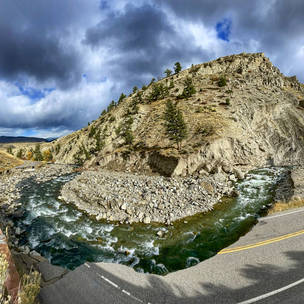
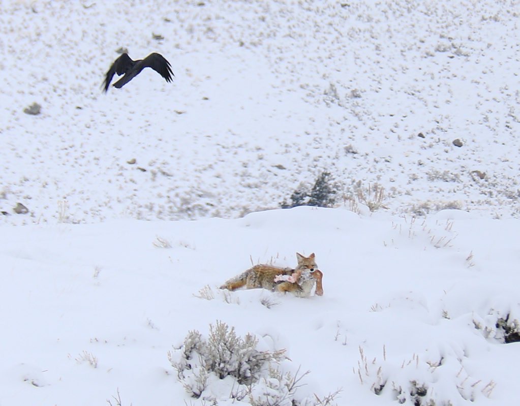
You may have heard about this road after the 2022 floods. This road used to connect Gardiner, Montana to Mammoth Hot Springs but washed away in the 2022 floods. While the road no longer fully connects to the rest of the park, it can still be wandered on foot for a few miles. Starting near the North Entrance Station, you’ll wander along the snow-covered old road, passing views of the Gardner River before getting to the first washout one mile in. You’ll more than likely have bison and elk around this first mile, so the going may be slow to stay appropriate distances from them. DO NOT GET CLOSER THAN 25 YARDS!
While many will turn around at the mile mark and first washout, those up for a bit more of a rugged adventure can continue on along a boot path to washout sections further up. In total, you can get about four miles of activity along this route, but some sections toward the end may be sketchy. After the first washout, you’ll have a chance to see eagles and even bighorn sheep, as well as possible coyote and fox encounters. DO NOT GET CLOSER THAN 25 YARDS!
Want to snowshoe this with a local, knowledgeable guide? Book your tour here!
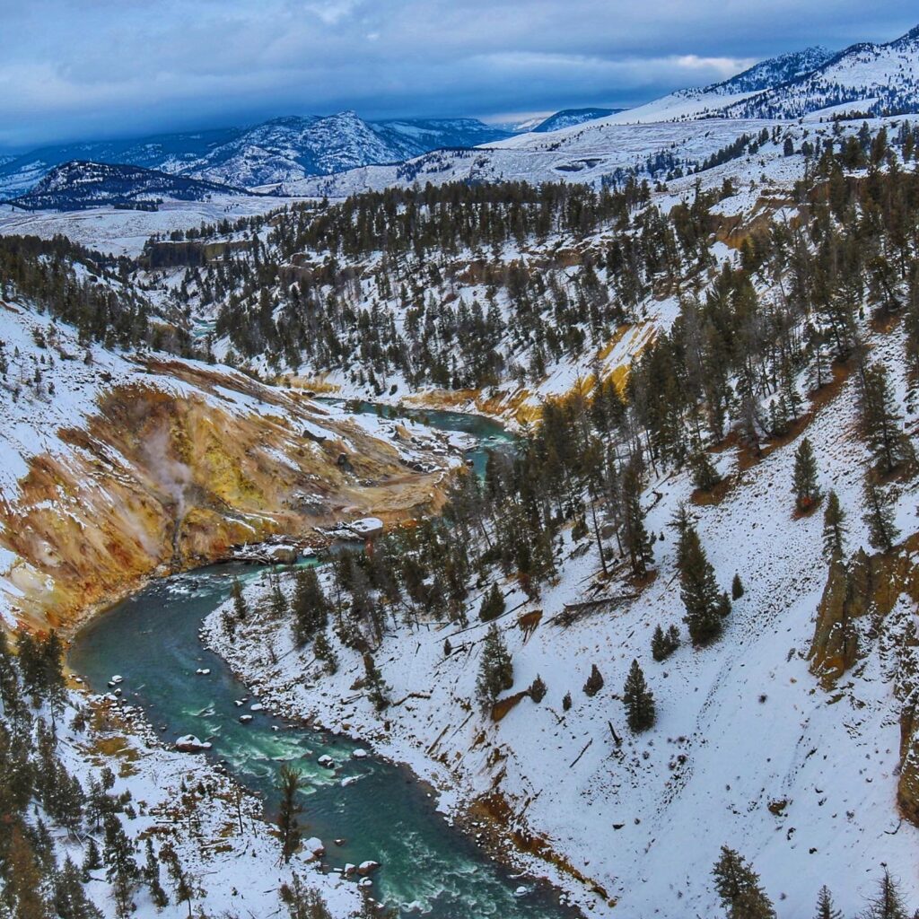
 Mammoth Hot Springs Upper Terrace
Distance: 2.2 miles
Elevation Gain: ~300ft
Gear Needed: Snowshoes/Cross Country Skis
Possible Wildlife: Deer, Elk, Bison, Rabbits
Highlights: Geothermal wonders of all shapes and sizes
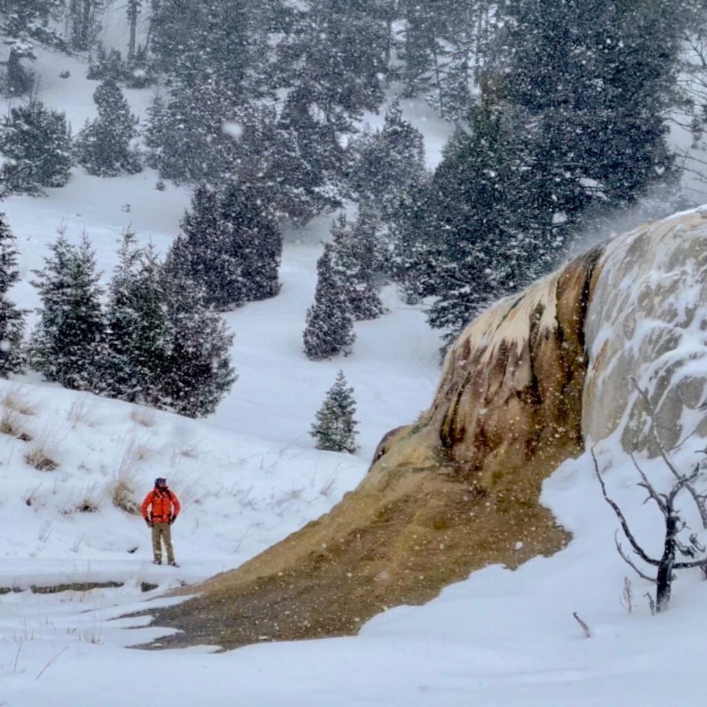
It is undeniable that the most impressive geothermal features of the park are located down in the interior, the Upper Terrace at Mammoth is a nice substitute and much less expensive than booking a tour down to the geyser basins. This short and occasionally steeper-than-you-expect loop route is a great little jaunt, getting you up close and personal with a few of the park’s memorable features. For cross-country skiers, this loop trail is one you can do a handful of times to get a fantastic workout. For snowshoers, this trail is a great introduction to the region, as well as a chance to get to some of the lesser-seen winter sights. Those who book a snowshoe tour with me will also be taken to a few geothermal spots not erectly on the loop, giving a glimpse at sights unseen by the masses.
Be aware the Upper Terrace Loop is for snowshoers and cross-country skiers only! Those with boots and shoes can still wander the boardwalks, including the iconic colors at Canary Spring. Please stay in the appropriate parts of the road for your footwear, as there are designated tracks for cross-country skiers and for snowshoers.
Want to snowshoe this with a local, knowledgeable guide? Book your tour here!
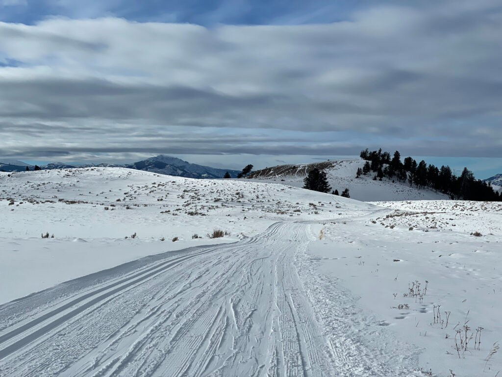
Blacktail Plateau
Distance: ~4 to 16 miles
Elevation Gain: Up to 900ft
Gear Needed: Snowshoes/Cross Country Skis
Possible Wildlife: Bison, elk, coyotes, wolves
Highlights: Remoteness, wildlife sightings, animal tracks,
Largely overlooked for the more well-known winter trails, Blacktail Plateau is a more leisurely, laid-back destination. While you won’t find frozen waterfalls, geothermal activity or endless sweeping views here, you will find a more realistic view of what Yellowstone’s backcountry is like in the winter. The route follows a seasonally open road, now long since closed and snow-covered. Weaving through a forest before coming to an open prairie, this route is popular for animal travel, full of wildlife tracks of all sizes. It isn’t uncommon to see wildlife here, such as bison, elk, and coyotes. It also isn’t uncommon to see wolf tracks along the route. When you aren’t looking own, the views here are great, giving mountain views above windswept prairies.
To travel this closed road, one can start at multiple places. I personally prefer the spot closest to Mammoth, as the parking area is larger and the elevation grade is less. While you can snowshoe or ski the whole trail, know it would be 16 16-mile round trip with 900 feet of elevation gain. Instead of doing that, I suggest heading out for 2.5 to 3 miles and heading back. That will give you a great feel for the trail, with over 400 feet of gain, without making it too long of a day.
Want to snowshoe this with a local, knowledgeable guide? Book your tour here!
Tower Falls and Calcite Springs
Distance: ~5 miles
Elevation Gain: ~500ft
Gear Needed: Snowshoes/Cross Country Skis
Possible Wildlife: Bison, coyotes, elk
Highlights: Stunning canyon views, wildlife, a frozen waterfall
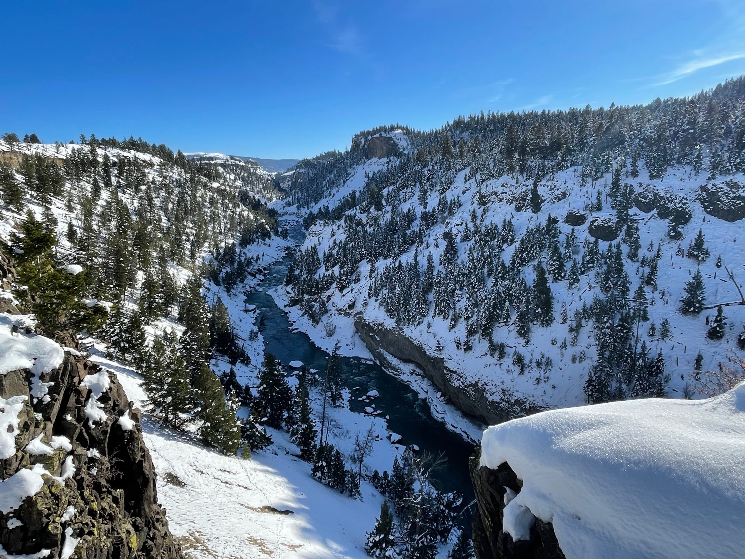
The route up to Tower Falls and Calcite Springs should be considered the quintessential winter trail experience in the Northern Range. Perfect for almost all levels of snowshoers and cross-country skiers, the route follows the snow-covered road to Tower Falls. Along the way, you’ll pass a mostly frozen pond, slightly bubbling from geothermal features, often with bison lingering nearby. Beyond that, you’ll continue to climb in elevation, reaching the can’t-miss views at the Calcite Springs Overlook. Some will skip this as they head to Tower Falls, but don’t be like them. For many, the sweeping views located along this quick stop are the highlight of the trail. Beyond Calcite Springs, the views continue. To the north, you’ll look almost directly down at the Yellowstone River far below. To the south, the rocks go straight up above you. Viewpoints are endless here and stopping often is suggested. Past the views, you’ll soon cross a frozen Tower Creek before reaching the closed-up gift shop at Tower Falls. A short path to the falls overlook presents itself, and following it, you’ll see a frozen Tower Falls in the distance.
Please stay in the appropriate parts of the road for your footwear, as there are designated tracks for cross-country skiers and for snowshoers.
Want to snowshoe this with a local, knowledgeable guide? Book your tour here!
Slough Creek
Distance: ~5 miles
Elevation Gain: ~200ft
Gear Needed: Snowshoes/Cross Country Skis
Possible Wildlife: Bison, coyotes, wolves
Highlights: Solitude, wildlife sightings, and potential once-in-a-lifetime experiences
If you haven’t adventured on Slough Creek Road in the winter, you are missing out on a classic trek. On this route from the parking area to the campground and back, you’ll more than likely see bison and have a great chance to see wolves and coyotes. If wolves aren’t visible, huge tracks in the snow certainly will be, telling you they were here recently. The trail is mainly rolling with minimal elevation gain, except for one larger 60-foot hill near the start and end. Along the trail, you’ll see endless animal tracks, amazing wind-blown snow formations, wildlife, and the gorgeousness of the Slough Creek region. On a clear day, you’ll also have mountain views in the distance, helping to show the size and scale of the northern range. While wildlife sightings are not guaranteed, this is the most consistent spot for seeing wolves and coyotes that I have snowshoed and cross-country skied. Definitely bring a pair of binoculars, stay relatively quiet, and always be alert. You never know what may be popping up over one of the many hills and ridges.
Want to snowshoe this with a local, knowledgeable guide? Book your tour here!
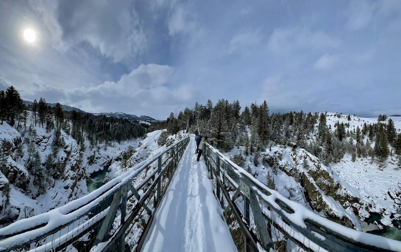
Hellroaring
Distance: ~5 miles
Elevation Gain: ~1000ft
Gear Needed: Snowshoes/Cross Country Skis
Possible Wildlife: Bison, coyotes, wolves
Highlights: Solitude, a suspension bridge, wildlife sightings, and potential once-in-a-lifetime experiences
Located between Mammoth Hot Springs and the Roosevelt Junction, a winter adventure in Hellroaring is truly remarkable. While most winter trails see almost daily use, few seem to take the time or effort to venture down to the suspension bridge or to the views of the valley. Hellroaring is usually only seen from a roadside overlook where carloads of visitors unload and set up spotting scopes to scan for wildlife. This is where many park visitors have their first wolf sightings and while seeing it from the roadside stop is great, there is nothing like seeing wolves while hiking. Hellroaring is a truly special place and one you will want to return to all year long.
Want to snowshoe this with a local, knowledgeable guide? Book your tour here!
The Yellowstone River Overlook Trail
Distance: ~6 miles
Elevation Gain: ~1000ft
Gear Needed: Snowshoes/Cross Country Skis
Possible Wildlife: Bison, coyotes, bighorn sheep
Highlights: Solitude, stunning landscapes, river views, wildlife sightings, and potential once-in-a-lifetime experiences
This trail is a personal favorite and is gorgeous all year long. Whether it is snowy or not, a hike along this trail will give you a fantastic opportunity to take in the grandeur of the Yellowstone River, learn about the geology of the region, and even give you a chance to spot wildlife. Not only that, but you’ll also have an opportunity to look over some of the most stunning scenery the northern range has to offer. While the main trailhead at the Yellowstone River Picnic Area is closed for construction, the trek from the Specimen Ridge Trailhead nearby makes the reveal of the river and canyon that much more impressive.
Want to snowshoe this with a local, knowledgeable guide? Book your tour here!
Lava Creek Trail
Distance: ~6 miles
Elevation Gain: ~1000ft
Gear Needed: Snowshoes/Cross Country Skis
Possible Wildlife: Bison, coyotes, elk
Highlights: Solitude, a frozen waterfall stunning landscapes, river views, wildlife sightings, and potential once-in-a-lifetime experiences
Have you ever spotted a waterfall from a roadside turnout and wished you could get to the other side of the creek to stand on top of it? That is exactly what you get when you take a trek on the Lava Creek Trail. Following the paths of bison, elk, coyotes, and even wolves, the path skirts along Lava Creek before arriving at the top of Undine Falls. From here, you can call it a day (it is only a one-mile round trip hike) and take a glimpse and gander down toward Mammoth Hot Springs, or wander down the trail a bit to the confluence of the creek and the Gardner River, which is 5.5 miles round trip. The view from this spot is also stunning, showing off the bridge spanning the river, as well as Bunsen Peak and Mammoth.
Want to snowshoe this with a local, knowledgeable guide? Book your tour here!
***Bonus Adventure***
Pebble Creek Canyon
Distance: ~1 mile
Elevation Gain: ~50ft
Gear Needed: Snowshoes/Boots
Possible Wildlife: Bison, foxes, ermine, coyotes, moose
Highlights: Awesome geology, cool ice formations, potential wildlife sightings and a feeling of solitude
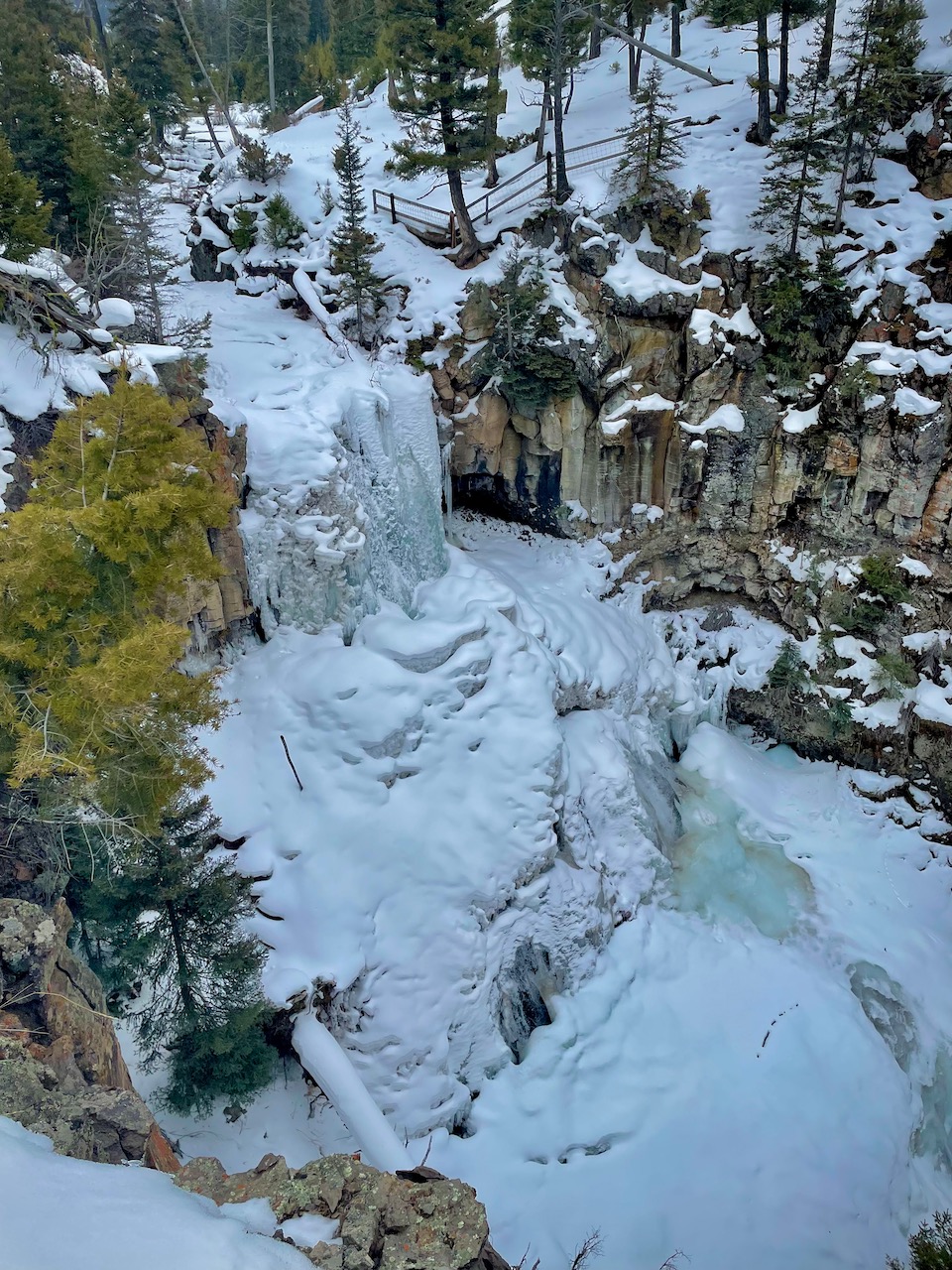
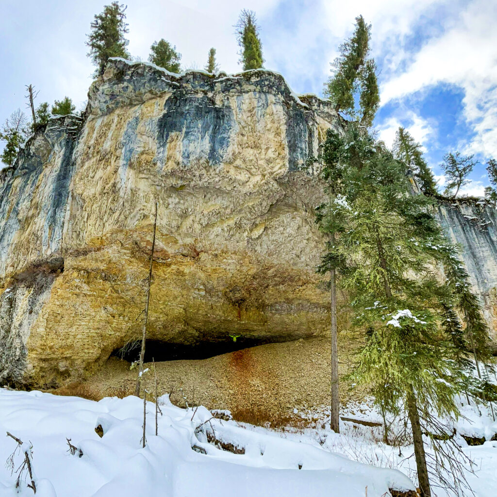
This short and sweet trail is perfect for those hoping for a quick jaunt into the winter wonderland of Yellowstone. It’s typically a well-traveled path, so you could do this in boots with good traction. After hiking through the snow at the washed-away Pebble Creek Parking Area and Campground, you’ll reach the partially frozen and snow-covered creek. The trail can be hard to locate, but those following the creek upstream will find themselves heading toward a large canyon, full of ice formations, animal tracks, and even a hidden cave. The trail is a geological wonderland, showing off the eons of erosion the region has endured. Be aware that the route is partially along a frozen creek and during warm periods, as well as the early and late winter months, the ice will be less than reliable. Also, know that you’ll more than likely have to park at the pullout to the east of the bridge and walk back to the start of this route. On the first half of the hike, be on the lookout for moose, as they frequent this section of the park and occasionally are lying under trees next to the trail.
Please note that this is NOT the Pebble Creek Trail!
Google Map
Trail Etiquette
Do not snowshoe or walk directly on ski tracks.
Skiers/snowshoers going uphill yield to those going downhill.
Fill in depressions in the snow after falling to reduce hazards to others.
Ski and snowshoe within your ability. If you find the trail too difficult, turn back
Finally
These are definitely not the only routes to travel on in the winter. There are at least a half dozen others I know and love, including trails to suspension bridges, more frozen waterfalls, out into Lamar Valley and even on an overlooked canyon rim trail or two. If you are hoping for one of these, or something a little more off the beaten path, please do not hesitate to reach out to me. I will help you find the perfect winter adventure in Yellowstone’s Northern Range, be it with your party, or by booking a snowshoe tour with me.